


ROQUESTÉRON - AIGLUN - 11KM

jpb83
User
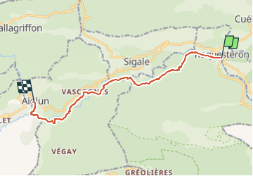

Length
11 km

Max alt
585 m

Uphill gradient
494 m
Km-Effort
16.8 km

Min alt
319 m

Downhill gradient
237 m
Boucle
No
Creation date :
2022-11-18 18:41:04.679
Updated on :
2022-11-18 18:41:07.67
3h48
Difficulty : Easy

FREE GPS app for hiking
 SityTrail
IGN / Geographical institutes
SityTrail Plus
The world is yours!
About
Trail Walking of 11 km to be discovered at Provence-Alpes-Côte d'Azur, Maritime Alps, La Roque-en-Provence. This trail is proposed by jpb83.
Positioning
Country:
France
Region :
Provence-Alpes-Côte d'Azur
Department/Province :
Maritime Alps
Municipality :
La Roque-en-Provence
Location:
Unknown
Start:(Dec)
Start:(UTM)
339775 ; 4859657 (32T) N.
Comments
ATTENTION la passerelle avant Vascogne n'est plus en fonction, il faut passer par la rivière tres bien en été, beaucoup moins l'hiver.